Geography
Paper 1 | Objectives | 50 Questions
WASSCE/WAEC MAY/JUNE
Year: 2020
Level: SHS
Time:
Type: Question Paper
Answers provided
FREE
No description provided
Feedbacks
This paper is yet to be rated
Paper 1 | Objectives | 50 Questions
WASSCE/WAEC MAY/JUNE
Year: 2020
Level: SHS
Time:
Type: Question Paper
Answers provided
No description provided
This paper is yet to be rated
| # | Question | Ans |
|---|---|---|
|
|
||
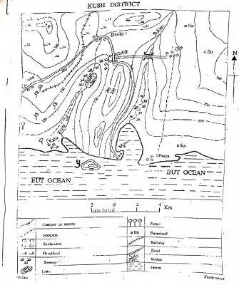
| 1. |
The scale of the map is A. 1cm to +km B. 1cm to 1km C. 1cm to 2km D. 2cm to 3km |
B |
| 2. |
The height at point P is about A. 275m B. 300m C. 375m D. 450m |
C |
| 3. |
The countour interval on the map is A. 50m B. 150m C. 200m D. 250m |
A |
| 4. |
What is the approximate distance from Obasa to Oju as the crowflies? A. 10km B. 18km C. 20km D. 25km |
A |
| 5. |
The bearing of Danki from Oju is A. 90° B. 150° C. 285° D. 355° |
C |
| 6. |
The feature in the south-west of Musa is A. a cliff B. an island C. a cave D. an inselberg |
A |
| 7. |
The lower section of R. Kam is showing signs of old stage because of the presence of A. spur B. levee C. pothole D. meander |
D |
| 8. |
Musa settlement is likely to be A. an airpot B. a fishing village C. a confluence town D. a nodal town |
B |
| 9. |
A seaport can be sited in all the following settlements except A. Kalu B. Musa C. Obasa D. Bama |
D |
| 10. |
All the following settlements are intervisible from KUSH except A. Oju B. Danki C. Musa D. Kalu |
C |
Preview displays only 10 out of the 50 Questions