
Geography
Paper 1 | Objectives | 50 Questions
WASSCE/WAEC MAY/JUNE
Year: 2017
Level: SHS
Time:
Type: Question Paper
Answers provided
FREE
No description provided
Feedbacks
This paper is yet to be rated
Paper 1 | Objectives | 50 Questions
WASSCE/WAEC MAY/JUNE
Year: 2017
Level: SHS
Time:
Type: Question Paper
Answers provided
No description provided
This paper is yet to be rated
| # | Question | Ans |
|---|---|---|
| 1. |
 The scale of the map above in representative fraction (RF) is A. 1 : 25,000 B. 1 : 50,000 C. 1 : 150,000 D. 1 : 250,000 |
B |
| 2. |
 The crowfly distance from Doba to Sasi is approximately A. 7.5km B. 6.0km C. 5.5km D. 4.5km |
C |
| 3. |
 What is the direction of IREWA and Oki? A. North-east B. North C. South D. South-East |
D |
| 4. |
 The symbol A950 to the north-east of IREWA is A. bench mark B. spot height C. beacon D. trigonometrical station |
D |
| 5. |
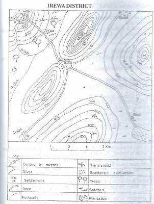 The feature marked H on the map can best be described as a A. plateau B. conical hill C. scarp D. ridge |
B |
| 6. |
 Which of the following settlements is located at the highest altitude? A. Doba B. Duba C. Sasi D. Oki |
D |
| 7. |
 The most likely occupation of the people of Oki is A. fishing B. mining C. farming D. lumbering |
C |
| 8. |
 Which of the following best explains the growth of IREWA? A. Nodal town B. Centre of plantation agriculture C. Good climate D. Industrial town |
A |
| 9. |
The most probable reason for the construction of the road from IREWA through Sasi to the plantation is A. because a large percentage of the population lives in Sasi B. to provide a means of transporting fish from Sasi to IREWA C. to carry the farmers from Sasi to IREWA D. to evacuate farm products from the plantation to the market at IREWA |
D |
| 10. |
 Which of the following towns may not be visible from the feature marked H? A. Sasi B. Doba C. Duba D. Oki |
D |
Preview displays only 10 out of the 50 Questions