
Geography
Paper 1 | Objectives | 50 Questions
WASSCE/WAEC MAY/JUNE
Year: 2016
Level: SHS
Time:
Type: Question Paper
Answers provided
FREE
No description provided
Feedbacks
This paper is yet to be rated
Paper 1 | Objectives | 50 Questions
WASSCE/WAEC MAY/JUNE
Year: 2016
Level: SHS
Time:
Type: Question Paper
Answers provided
No description provided
This paper is yet to be rated
| # | Question | Ans |
|---|---|---|
| 1. |
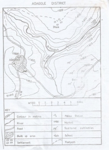 The scale of the map in statement form is A. 1 centimetres on the map represents 1 kilometre on the ground B. 2 centimetres on the map represent 1 kilometre on the ground C. 3 centimetres on the map represent 1 kilometre on the ground D. 4 centimetres on the map represent 1 kilometre on the ground |
A |
| 2. |
 Farming is common in A. North Western part of the map B. North Eastern part of the map C. South Western part of the map D. South Eastern part of the map |
D |
| 3. |
 The western part of R. Gembeh flows through A. A delta B. A gorge C. A levee D. An undulating plain |
B |
| 4. |
 The point where R.Isbo meets R.Gembeh is called A. An entrepot B. A watershed C. A lagoon D. A confluence |
D |
| 5. |
 The contour interval on the map is A. 50 metres B. 100 metres C. 150 metres D. 200 metres |
A |
| 6. |
 The lowest point in the map is in the A. South-east B. North-east C. South-west D. North-west |
B |
| 7. |
 The distance as the crow flies from Bebe to Bodel is A. 12.75km B. 10.00km C. 7.25km D. 5.25km |
B |
| 8. |
 The bearing of Bodel from Bebe is A. 25.0 B. 255.0 C. 115.0 D. 150.0 |
B |
| 9. |
 Which of the following statements is true about the drainage of the mapped area? A. The watershed from which the rivers take their sources is in the North West B. R.Isbo and R.Gembeh are the rivers that drain the distrint C. R.Gembeh has many distributaries D. An oxbow lake has been formed at the point of intersection of R.Isbo and R.Gembeh |
B |
| 10. |
 The common modes of transportation in the mapped area are A. Railway and water B. Pipeline and railway C. Road and water D. Air and water |
C |
Preview displays only 10 out of the 50 Questions