
Geography
Paper 1 | Objectives | 50 Questions
WASSCE/WAEC MAY/JUNE
Year: 2015
Level: SHS
Time:
Type: Question Paper
Answers provided
FREE
No description provided
Feedbacks
This paper is yet to be rated
Paper 1 | Objectives | 50 Questions
WASSCE/WAEC MAY/JUNE
Year: 2015
Level: SHS
Time:
Type: Question Paper
Answers provided
No description provided
This paper is yet to be rated
| # | Question | Ans |
|---|---|---|
| 1. |
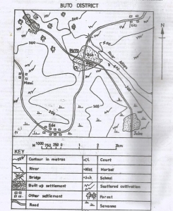 What is the scale of the map in statement form? A. One centimeter on the map represents half a kilometer on the ground B. One centimeter on the map represents one and half kilometers on the ground C. One centimeter on the ground represents two kilometers on the ground D. One centimeter on the map represents four kilometers on the ground |
A |
| 2. |
 What is the approximate distance as the crow flies from Mami to Esho? A. 312.0 km B. 9.0 km C. 3.0 km D. 1.5 km |
C |
| 3. |
 Which of the following settlements performs administrative function? A. Jaba B. Ede C. Buto D. Ititi |
C |
| 4. |
 In which part of the mapped area is lumbering a likely economic activity? A. Northeast B. Southeast C. Southwest D. Northwest |
D |
| 5. |
 What is the direction of flow of River Afikpo? A. Southwest B. Northeast C. Northwest D. Southeast |
C |
| 6. |
 What is the settlement of Ede? A. Isolated B. Dispersed C. Annular D. Linear |
D |
| 7. |
 What is the contour interval of the map? A. 25 metres B. 50 metres C. 100 metres D. 150 metres |
C |
| 8. |
 Which economic activity could be practiced in the south-eastern part of mapped area? A. Animal rearing B. Lumbering C. Trading D. Mining |
A |
| 9. |
 Which of the following modes of transport is commonly used in the mapped area? A. River B. Road C. Rail D. Air |
B |
| 10. |
 The distance by road from Mami to Buto is approximately_____? A. 9.0 km B. 14.0 km C. 23.0 km D. 25.0 km |
A |
Preview displays only 10 out of the 50 Questions