
Geography
Paper 1 | Objectives | 50 Questions
WASSCE/WAEC MAY/JUNE
Year: 2019
Level: SHS
Time:
Type: Question Paper
Answers provided
FREE
No description provided
Feedbacks
This paper is yet to be rated
Paper 1 | Objectives | 50 Questions
WASSCE/WAEC MAY/JUNE
Year: 2019
Level: SHS
Time:
Type: Question Paper
Answers provided
No description provided
This paper is yet to be rated
| # | Question | Ans |
|---|---|---|
| 1. |
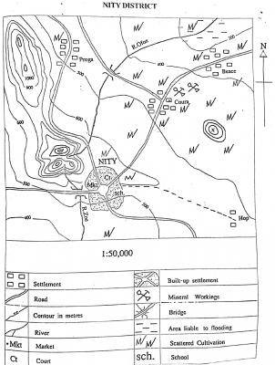 What is the contour interval of the map? A. 50 m B. 100 m C. 150 m D. 400 m |
B |
| 2. |
 What is the scale of the map in statement form? A. one centimeter on the map represents half kilometer on the ground B. One centimeter on the map represents one kilometer on the ground. C. One centimeter on the map represents five kilometers on the ground D. One centimeter on the map represents fifteen kilometers on the ground. |
A |
| 3. |
 The approximate length of R. Ofon is A. 18.3 km B. 16.5 km C. 6.6 km D. 3.0 km |
A |
| 4. |
 Which of the following settlements is nodal? A. Beace B. Hop C. Proga D. NITY |
D |
| 5. |
 The highest elevation in the mapped area is approximately A. 800 m B. 900 m C. 1250 m D. 1400 m |
C |
| 6. |
 What is the relief feature marked X? A. Ridge B. Plateau C. Knoll D. Gorge |
C |
| 7. |
 If the map of NITY DISTRICT is reduced to half, what will be the scale of the new map in Representative Fraction (RF)? A. 1: 25,000 B. 1 : 50,000 C. 1 : 100,000 D. 1 : 150,000 |
C |
| 8. |
 The relief feature on the west of NITY which extends to the north-western corner of the map is a A. gorge B. plain C. plateau D. ridge |
D |
| 9. |
 In which settlement is mining practised in the mapped area? A. NITY B. Hop C. Coura D. Proga |
C |
| 10. |
 Where can civil conflicts be resolved in the District? A. Proga B. Coura C. Hop D. NITY |
D |
Preview displays only 10 out of the 50 Questions