Year :
1986
Title :
Geography
Exam :
JAMB Exam
Paper 1 | Objectives
41 - 50 of 50 Questions
| # | Question | Ans |
|---|---|---|
| 41. |
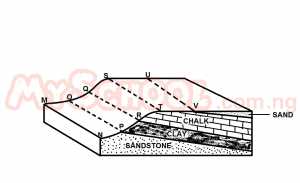 The figure above shows a cuesta landscape. Along which of the lines are spring likely to be found? A. MN B. OP C. QR D. ST |
C |
| 42. |
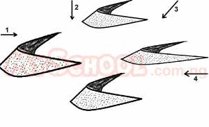 The figure above shows a desert landform. Which of the following wind direction is likely to have been responsible for its formation? A. 1 B. 2 C. 3 D. 4 |
A |
| 43. |
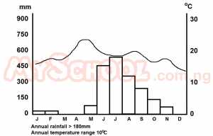 In addition to rice which crop combination can be ideally grown in the climatic region depicted in the graph above? A. surghum and coffee B. jute and tea C. oil palm and cotton D. olives and tea |
B |
| 44. |
 The graph above shows the birth and death in a country over a period of time. At what point was the population increase most rapid? A. zero B. 1 C. 2 D. 3 |
D |
| 45. |
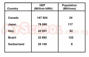 Which of the following observation can be inferred from the table above, which the hydro-electric power (HEP) development in some selected countries? A. More HEP stations are built in canada than in Japan B. Per capital HEP consumption is higher in Switzerland than in Italy C. Power from hydro-electricity is cheaper than power from other sources D. More factories uses HEP in Brazil than in Switzerland |
B |
| 46. |
 Ruwawa is located in A. A tropical area in the Southern Hemisphere B. An Equatorial area in the Southern Hemisphere C. An Equatorial area in the Northern Hemisphere D. A subtropical area in the Northern Hemisphere |
B |
| 47. |
 The most important factor in the economy of Ruwawa is A. Forestry B. Water Resources C. Transportation D. Agriculture |
D |
| 48. |
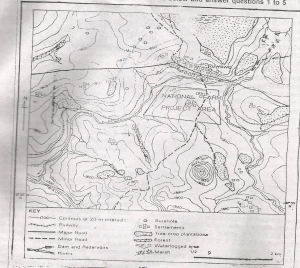 The highest elevation above sea level is found on Juju Hill and is approximately A. 1965m B. 1985m C. 2005m D. 2025m |
D |
| 49. |
 The length of the major road in Ruwawa is approximately A. 7km B. 9km C. 11km D. 13km |
B |
| 50. |
 The inhabitants of the area north of the major road in Ruwawa rely more on ground water than on surface reservoirs because A. The large plantations use up all the surface water B. The reservoirs have been reduced to marshes C. There are mainly boreholes in the area D. The surface water has been diverted to serve the National Farm Project Area |
B |
| 41. |
The figure above shows a cuesta landscape. Along which of the lines are spring likely to be found? A. MN B. OP C. QR D. ST |
C |
| 42. |
The figure above shows a desert landform. Which of the following wind direction is likely to have been responsible for its formation? A. 1 B. 2 C. 3 D. 4 |
A |
| 43. |
In addition to rice which crop combination can be ideally grown in the climatic region depicted in the graph above? A. surghum and coffee B. jute and tea C. oil palm and cotton D. olives and tea |
B |
| 44. |
The graph above shows the birth and death in a country over a period of time. At what point was the population increase most rapid? A. zero B. 1 C. 2 D. 3 |
D |
| 45. |
Which of the following observation can be inferred from the table above, which the hydro-electric power (HEP) development in some selected countries? A. More HEP stations are built in canada than in Japan B. Per capital HEP consumption is higher in Switzerland than in Italy C. Power from hydro-electricity is cheaper than power from other sources D. More factories uses HEP in Brazil than in Switzerland |
B |
| 46. |
Ruwawa is located in A. A tropical area in the Southern Hemisphere B. An Equatorial area in the Southern Hemisphere C. An Equatorial area in the Northern Hemisphere D. A subtropical area in the Northern Hemisphere |
B |
| 47. |
The most important factor in the economy of Ruwawa is A. Forestry B. Water Resources C. Transportation D. Agriculture |
D |
| 48. |
The highest elevation above sea level is found on Juju Hill and is approximately A. 1965m B. 1985m C. 2005m D. 2025m |
D |
| 49. |
The length of the major road in Ruwawa is approximately A. 7km B. 9km C. 11km D. 13km |
B |
| 50. |
The inhabitants of the area north of the major road in Ruwawa rely more on ground water than on surface reservoirs because A. The large plantations use up all the surface water B. The reservoirs have been reduced to marshes C. There are mainly boreholes in the area D. The surface water has been diverted to serve the National Farm Project Area |
B |