Year :
2002
Title :
Geography
Exam :
JAMB Exam
Paper 1 | Objectives
41 - 50 of 50 Questions
| # | Question | Ans |
|---|---|---|
|
|
||
| 41. |
The climatic data above is likely to be that of A. Warri B. Lokoja C. Ibadan D. Kaduna |
B |
| 42. |
 The feature marked X in the diagram is a A. beach B. spit C. stack D. cliff |
C |
| 43. |
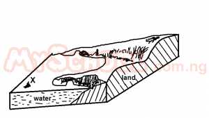 The feature is one of the landforms association with A. wind deflation B. wave erosion C. river erosion D. wind deposition |
C |
| 44. |
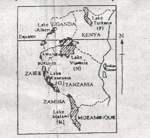 The lake marked N is mostly used for A. Transportation and irrigation B. Transportation and fishing C. Tourism and domestic water supply D. Tourism and HEP generation |
B |
| 45. |
 A common feature of the lakes marked F,G,H is that they are A. Used for HEP B. Located very close to the equator C. Located within the East African Rift Valley D. Very shallow |
C |
| 46. |
 The Oke-Hatis Road passes through the floodable plain of River Haba by means of A. A flyover B. An embankment C. An underground passage D. A road cutting |
B |
| 47. |
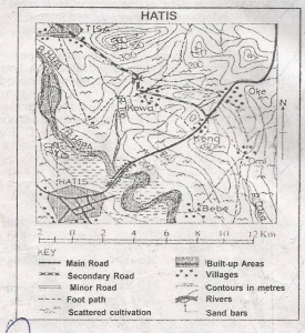 The length of the secondary road on the map is approximately A. 11.5km B. 12.5km C. 13.5km D. 10.5km |
C |
| 48. |
 The main occupation of the people in the area on the map is most likely to be A. Fishing B. Lumbering C. Mining D. Farming |
D |
| 49. |
 The feature marked Y north of Hatis is A. An ox-bow lake B. An isolated hill C. A depression D. A sand bar |
A |
| 50. |
 The most prominent feature of River Haba downstream of the bridge is a A. Levee B. Knick point C. Meander D. Braid |
C |

|
|
||
| 41. |
The climatic data above is likely to be that of A. Warri B. Lokoja C. Ibadan D. Kaduna |
B |
| 42. |
The feature marked X in the diagram is a A. beach B. spit C. stack D. cliff |
C |
| 43. |
The feature is one of the landforms association with A. wind deflation B. wave erosion C. river erosion D. wind deposition |
C |
| 44. |
The lake marked N is mostly used for A. Transportation and irrigation B. Transportation and fishing C. Tourism and domestic water supply D. Tourism and HEP generation |
B |
| 45. |
A common feature of the lakes marked F,G,H is that they are A. Used for HEP B. Located very close to the equator C. Located within the East African Rift Valley D. Very shallow |
C |
| 46. |
The Oke-Hatis Road passes through the floodable plain of River Haba by means of A. A flyover B. An embankment C. An underground passage D. A road cutting |
B |
| 47. |
The length of the secondary road on the map is approximately A. 11.5km B. 12.5km C. 13.5km D. 10.5km |
C |
| 48. |
The main occupation of the people in the area on the map is most likely to be A. Fishing B. Lumbering C. Mining D. Farming |
D |
| 49. |
The feature marked Y north of Hatis is A. An ox-bow lake B. An isolated hill C. A depression D. A sand bar |
A |
| 50. |
The most prominent feature of River Haba downstream of the bridge is a A. Levee B. Knick point C. Meander D. Braid |
C |