Year :
1979
Title :
Geography
Exam :
JAMB Exam
Paper 1 | Objectives
1 - 10 of 50 Questions
| # | Question | Ans |
|---|---|---|
| 1. |
 What is the length to the nearest kilometer of the main stream that flows into the Lake Lagoon? A. 4 kilometers B. 8 kilometers C. 10 kilometers D. 12 kilometers |
B |
| 2. |
 The elevated feature that runs westwards from the cape near Mito to the western edge of the map is A. a hill B. a spur C. a ridge D. a cuesta E. a peninsula |
C |
| 3. |
 The true bearing of the trigonometrical station 54.0m from the peak of Bedi Hill is A. 127° B. 200° C. 233° D. 266° E. 319° |
C |
| 4. |
 The appropriate geographical term for that narrow feature east of Ela Lagoon along which a footpath runs is A. lake B. ocean C. bach sand D. isthmus E. sand bar |
C |
| 5. |
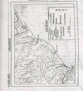 What is the approximate height of Manko above the sea level? A. 46.0m B. 35.0m C. 30.0m D. 21.0m E. 12.0m |
B |
| 6. |
Which of the following scales should show the greatest amount of detail on a map? A. 1:2500 000 B. 1:63 360 C. 1:32 D. 1:160 934 E. 1:2 |
E |
| 7. |
Rotation of the earth is A. the movement of the earth in the atmosphere B. the movement of the earth on its axis C. the movement of the earth around the sun D. the movement of the moon round the earth E. the movement of the earth on its orbit |
B |
| 8. |
The direct cause of waves is A. a difference in the density of ocean water B. the great heat of the sun C. the wind D. difference in depth of the ocean floor E. change in the phase of the moon |
C |
| 9. |
Which of the following is not a form of precipitation? A. Snow B. Sleet C. Fog D. Hail E. Haze |
E |
| 10. |
The sea bed, bordering the continents, which is covered by shallow water is known as A. continental slope B. coral reef C. continental platform D. continental drift E. continental shelf |
E |
| 1. |
What is the length to the nearest kilometer of the main stream that flows into the Lake Lagoon? A. 4 kilometers B. 8 kilometers C. 10 kilometers D. 12 kilometers |
B |
| 2. |
The elevated feature that runs westwards from the cape near Mito to the western edge of the map is A. a hill B. a spur C. a ridge D. a cuesta E. a peninsula |
C |
| 3. |
The true bearing of the trigonometrical station 54.0m from the peak of Bedi Hill is A. 127° B. 200° C. 233° D. 266° E. 319° |
C |
| 4. |
The appropriate geographical term for that narrow feature east of Ela Lagoon along which a footpath runs is A. lake B. ocean C. bach sand D. isthmus E. sand bar |
C |
| 5. |
What is the approximate height of Manko above the sea level? A. 46.0m B. 35.0m C. 30.0m D. 21.0m E. 12.0m |
B |
| 6. |
Which of the following scales should show the greatest amount of detail on a map? A. 1:2500 000 B. 1:63 360 C. 1:32 D. 1:160 934 E. 1:2 |
E |
| 7. |
Rotation of the earth is A. the movement of the earth in the atmosphere B. the movement of the earth on its axis C. the movement of the earth around the sun D. the movement of the moon round the earth E. the movement of the earth on its orbit |
B |
| 8. |
The direct cause of waves is A. a difference in the density of ocean water B. the great heat of the sun C. the wind D. difference in depth of the ocean floor E. change in the phase of the moon |
C |
| 9. |
Which of the following is not a form of precipitation? A. Snow B. Sleet C. Fog D. Hail E. Haze |
E |
| 10. |
The sea bed, bordering the continents, which is covered by shallow water is known as A. continental slope B. coral reef C. continental platform D. continental drift E. continental shelf |
E |