Year :
1983
Title :
Geography
Exam :
JAMB Exam
Paper 1 | Objectives
41 - 50 of 50 Questions
| # | Question | Ans |
|---|---|---|
| 41. |
Which of the main crop growth in the Ghezira plains? A. Wheat B. Millet C. Cotton D. Rice E. Sugarcane |
C |
| 42. |
Which of the following statement is NOT true of all the highland regions of Rwanda-Burundi, Kenya and Ethiopia? A. There is heavy pressure of population on land B. There is serveral soil erosion C. There is heavy fragmentation of land among the farmers D. Coffee is the main cash crop E. There are many hydro-electric power stations |
E |
| 43. |
 The above diagram shows the position of the Earth in relation to the sun on June 21st. The earth's axis is inclined from the vertical at an angle A. 231/2o B. 451/2o C. 661/2o D. 721/2o E. 861/2o |
C |
| 44. |
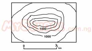 The above diagram on which the contour are in metres, shows a A. drumlin B. knoll C. volcanic cone D. Block mountain E. mesa |
B |
| 45. |
 The ocean currents marked X and Y are the A. Cold Saharan Current and cold Namibian current B. Warm canaries Current an dwarm Bengueka current C. Warm gulk-stream and warm Humbolt current D. Cool Cnaries current and cool Benguela current E. Warm canaries current and cool mozambique current |
D |
| 46. |
 What type of climate experienced in the region 'P' shaded on the map A. Cool temperate Western Margin B. Tropical Marina C. Tropical Monsoon D. Mediterranean E. Tropical continental |
D |
| 47. |
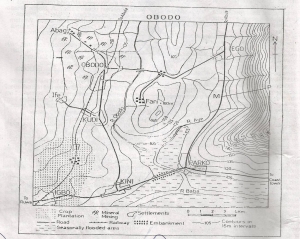 The length of the railway line shown on obodo map is A. 13.75km B. 16.75km C. 19.75km D. 22.75km E. 25.75km |
A |
| 48. |
 The location of the spot height(160m) east of fari near the centre of the map of obodo may be described as a A. Col B. Pass C. Road gap D. Wind E. Spur |
A |
| 49. |
 A profile drawn along M-P east of Parko - Ego road on the map describes a A. Ridge B. Scarp C. Concave slope D. Convex slope E. Broken ridge |
C |
| 50. |
 The drainage pattern of the area shown on the map is best described as A. Dendritic B. Radial C. Trellis D. Rectangular E. Annular |
C |
| 41. |
Which of the main crop growth in the Ghezira plains? A. Wheat B. Millet C. Cotton D. Rice E. Sugarcane |
C |
| 42. |
Which of the following statement is NOT true of all the highland regions of Rwanda-Burundi, Kenya and Ethiopia? A. There is heavy pressure of population on land B. There is serveral soil erosion C. There is heavy fragmentation of land among the farmers D. Coffee is the main cash crop E. There are many hydro-electric power stations |
E |
| 43. |
The above diagram shows the position of the Earth in relation to the sun on June 21st. The earth's axis is inclined from the vertical at an angle A. 231/2o B. 451/2o C. 661/2o D. 721/2o E. 861/2o |
C |
| 44. |
The above diagram on which the contour are in metres, shows a A. drumlin B. knoll C. volcanic cone D. Block mountain E. mesa |
B |
| 45. |
The ocean currents marked X and Y are the A. Cold Saharan Current and cold Namibian current B. Warm canaries Current an dwarm Bengueka current C. Warm gulk-stream and warm Humbolt current D. Cool Cnaries current and cool Benguela current E. Warm canaries current and cool mozambique current |
D |
| 46. |
What type of climate experienced in the region 'P' shaded on the map A. Cool temperate Western Margin B. Tropical Marina C. Tropical Monsoon D. Mediterranean E. Tropical continental |
D |
| 47. |
The length of the railway line shown on obodo map is A. 13.75km B. 16.75km C. 19.75km D. 22.75km E. 25.75km |
A |
| 48. |
The location of the spot height(160m) east of fari near the centre of the map of obodo may be described as a A. Col B. Pass C. Road gap D. Wind E. Spur |
A |
| 49. |
A profile drawn along M-P east of Parko - Ego road on the map describes a A. Ridge B. Scarp C. Concave slope D. Convex slope E. Broken ridge |
C |
| 50. |
The drainage pattern of the area shown on the map is best described as A. Dendritic B. Radial C. Trellis D. Rectangular E. Annular |
C |