Year :
1992
Title :
Geography
Exam :
JAMB Exam
Paper 1 | Objectives
41 - 50 of 50 Questions
| # | Question | Ans |
|---|---|---|
| 41. |
Which of the following group of countries constitutes the Chad Basin Commission? A. Benin, Niger, Nigeria and Chad B. Niger, Nigeria, Chad and Sudan C. Cameroon, Libya, Chad and Sudan D. Cameroon, Chad, Niger and Nigeria |
C |
| 42. |
An inter-zonal soil commonly found in arid regions are characterized by strong salt solutions that form white crusts on the surface, is a? A. Solonchak B. Solonetz C. Chernozem D. Podzol |
D |
| 43. |
In which of the following countries is cotton growing under irrigation the mainstay of the agricultural economy? A. Mali B. Zimbabwe C. Sudan D. Uganda |
C |
| 44. |
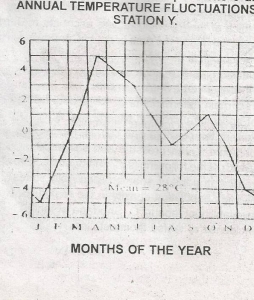 The temperature in the month of December at station Y is A. 4oC B. -4oC C. 24oC D. 32oC |
B |
| 45. |
 Monthly temperatures are above the average in A. 8months B. 7months C. 6months D. 5months |
D |
| 46. |
 Aperi is typically a A. Confluence town B. Dry point C. Wet point settlement D. Foothill settlement |
C |
| 47. |
 The feature marked J is a A. Valley B. Pass C. Col D. Shoulder |
C |
| 48. |
 The average gradient the slope marked L-K is approximately A. 1:15 B. 1:17 C. 1:19 D. 1:21 |
C |
| 49. |
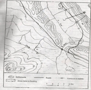 The roads in the area shown on the map appear to have been constructed mainly to avoid A. Footslopes B. Steep gradients C. Upland areas D. Building bridges |
B |
| 50. |
 Which type of land management is best suited for the area around Aperi? A. Terracing B. Contour Ploughing C. Afforestation D. Rreclamation |
D |
| 41. |
Which of the following group of countries constitutes the Chad Basin Commission? A. Benin, Niger, Nigeria and Chad B. Niger, Nigeria, Chad and Sudan C. Cameroon, Libya, Chad and Sudan D. Cameroon, Chad, Niger and Nigeria |
C |
| 42. |
An inter-zonal soil commonly found in arid regions are characterized by strong salt solutions that form white crusts on the surface, is a? A. Solonchak B. Solonetz C. Chernozem D. Podzol |
D |
| 43. |
In which of the following countries is cotton growing under irrigation the mainstay of the agricultural economy? A. Mali B. Zimbabwe C. Sudan D. Uganda |
C |
| 44. |
The temperature in the month of December at station Y is A. 4oC B. -4oC C. 24oC D. 32oC |
B |
| 45. |
Monthly temperatures are above the average in A. 8months B. 7months C. 6months D. 5months |
D |
| 46. |
Aperi is typically a A. Confluence town B. Dry point C. Wet point settlement D. Foothill settlement |
C |
| 47. |
The feature marked J is a A. Valley B. Pass C. Col D. Shoulder |
C |
| 48. |
The average gradient the slope marked L-K is approximately A. 1:15 B. 1:17 C. 1:19 D. 1:21 |
C |
| 49. |
The roads in the area shown on the map appear to have been constructed mainly to avoid A. Footslopes B. Steep gradients C. Upland areas D. Building bridges |
B |
| 50. |
Which type of land management is best suited for the area around Aperi? A. Terracing B. Contour Ploughing C. Afforestation D. Rreclamation |
D |