Year :
1990
Title :
Geography
Exam :
JAMB Exam
Paper 1 | Objectives
41 - 50 of 50 Questions
| # | Question | Ans |
|---|---|---|
| 41. |
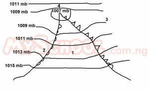 Rainfall would normally be expected at location A. 1 B. 2 C. 3 D. 4 |
B |
| 42. |
 In which direction will the winds blow? A. clockwise B. ani-clockwise C. parallel to the isobars D. at right angle to the isobars |
A |
| 43. |
 The agricultural products associated with the shaded areas are A. livestock and wheat B. timber and maize C. cattle and rice D. sheep and coffee |
A |
| 44. |
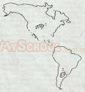 Region 1 is located in the A. Apalachians B. Great lake region C. Great plains D. Rockies |
D |
| 45. |
 Region 2 is located in the A. Amazon basin B. Pampas C. Campos D. Llanos |
B |
| 46. |
 The total length of River Kudi is approximately A. 22km B. 20km C. 18km D. 16km |
B |
| 47. |
 The channel of River Kudi is broad and A. Incised B. Graded C. Shallow D. U-shaped |
C |
| 48. |
 The general landscape of the area can be described as a A. Flood plain B. High plain C. Pediplain D. Peneplain |
A |
| 49. |
 Which of the following settlements has the grid reference 098172? A. Dan B. Biu C. Bika D. Maga |
D |
| 50. |
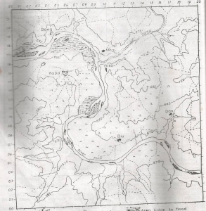 A major problem the settlements in this area are likely to face is that of? A. Poor drainage B. Poor accesibility C. Dense vegetation D. Infertile soils |
B |
| 41. |
Rainfall would normally be expected at location A. 1 B. 2 C. 3 D. 4 |
B |
| 42. |
In which direction will the winds blow? A. clockwise B. ani-clockwise C. parallel to the isobars D. at right angle to the isobars |
A |
| 43. |
The agricultural products associated with the shaded areas are A. livestock and wheat B. timber and maize C. cattle and rice D. sheep and coffee |
A |
| 44. |
Region 1 is located in the A. Apalachians B. Great lake region C. Great plains D. Rockies |
D |
| 45. |
Region 2 is located in the A. Amazon basin B. Pampas C. Campos D. Llanos |
B |
| 46. |
The total length of River Kudi is approximately A. 22km B. 20km C. 18km D. 16km |
B |
| 47. |
The channel of River Kudi is broad and A. Incised B. Graded C. Shallow D. U-shaped |
C |
| 48. |
The general landscape of the area can be described as a A. Flood plain B. High plain C. Pediplain D. Peneplain |
A |
| 49. |
Which of the following settlements has the grid reference 098172? A. Dan B. Biu C. Bika D. Maga |
D |
| 50. |
A major problem the settlements in this area are likely to face is that of? A. Poor drainage B. Poor accesibility C. Dense vegetation D. Infertile soils |
B |