Year :
2006
Title :
Geography
Exam :
JAMB Exam
Paper 1 | Objectives
41 - 50 of 50 Questions
| # | Question | Ans |
|---|---|---|
| 41. |
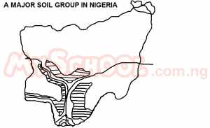 The shaded area is the A. Niger-Benue syncline B. Niger-Benue confluence C. Niger-Benue Basin D. Niger-Benue trough |
D |
| 42. |
 The main annual rainfall in the shaded area is A. 1600mm - 3200mm B. 800mm - 1600mm C. 400mm - 800mm D. above 3200mm |
A |
| 43. |
 The rains occur mainly as a result of A. south-east trade wind B. strong orographic effects C. north - east trade winds D. strong conventional currents |
D |
| 44. |
 The landform is the result A. compressional faulting and erosion B. tensional faulting only C. compressional faulting only D. tensional faulting and erosion |
C |
| 45. |
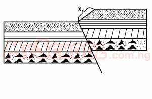 The slope identified as X is A. a rising limb B. an escarpment C. a fault scarp D. a fault-line scarp |
C |
| 46. |
 The landform marked X is a A. Gap B. Valley C. Saddle D. Trough |
B |
| 47. |
 The bearing of La'ah from Gambo is A. 60o B. 300o C. 30o D. 120o |
B |
| 48. |
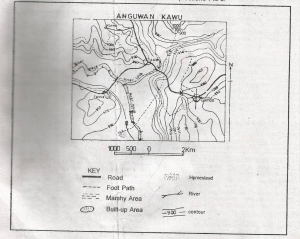 The major economic activity in the area is likely to be A. Fishing B. Lumbering C. Farming D. Pastoralism |
A |
| 49. |
 The total length of River Maya is approximately A. 7.5km B. 5.5km C. 8.5km D. 6.5km |
A |
| 50. |
 The relief pattern on the map reveals A. A dissected plateau B. A marshy land C. An undulating lowland D. An old river valley |
A |
| 41. |
The shaded area is the A. Niger-Benue syncline B. Niger-Benue confluence C. Niger-Benue Basin D. Niger-Benue trough |
D |
| 42. |
The main annual rainfall in the shaded area is A. 1600mm - 3200mm B. 800mm - 1600mm C. 400mm - 800mm D. above 3200mm |
A |
| 43. |
The rains occur mainly as a result of A. south-east trade wind B. strong orographic effects C. north - east trade winds D. strong conventional currents |
D |
| 44. |
The landform is the result A. compressional faulting and erosion B. tensional faulting only C. compressional faulting only D. tensional faulting and erosion |
C |
| 45. |
The slope identified as X is A. a rising limb B. an escarpment C. a fault scarp D. a fault-line scarp |
C |
| 46. |
The landform marked X is a A. Gap B. Valley C. Saddle D. Trough |
B |
| 47. |
The bearing of La'ah from Gambo is A. 60o B. 300o C. 30o D. 120o |
B |
| 48. |
The major economic activity in the area is likely to be A. Fishing B. Lumbering C. Farming D. Pastoralism |
A |
| 49. |
The total length of River Maya is approximately A. 7.5km B. 5.5km C. 8.5km D. 6.5km |
A |
| 50. |
The relief pattern on the map reveals A. A dissected plateau B. A marshy land C. An undulating lowland D. An old river valley |
A |