Year :
2011
Title :
Geography
Exam :
JAMB Exam
Paper 1 | Objectives
41 - 50 of 50 Questions
| # | Question | Ans |
|---|---|---|
| 41. |
Improved agricultural production in Cote d'Ivoire is mainly due to? A. abundant and relief rainfall B. good and effective transportation routes C. availability of migrant labour D. good organization and effective management |
D |
| 42. |
 If the total number of livestock is 6 million, what is the number of cattle produced A. 2,200,000 B. 2,300,000 C. 2,400,000 D. 2,500,000 |
C |
| 43. |
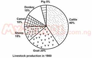 The total number of pigs, camels and donkeys is A. 1,600,000 B. 1,500,000 C. 1,400,000 D. 1,300,000 |
B |
| 44. |
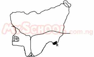 The area marked S is A. Western trough B. Western upland C. Obudu plateau D. Oban hills |
B |
| 45. |
 The Inhabitants of Abu are most likely to be A. Traders B. Farmers C. Cattle rearers D. Miners |
A |
| 46. |
 The distribution of settlements in the area is mostly influenced by A. Drainage B. Vegetation C. Relief D. Mineral deposits |
C |
| 47. |
 The spot height on the map is A. 320m B. 360m C. 400m D. 440m |
B |
| 48. |
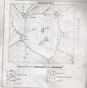 The area can be described as a A. Low plain B. Rugged relief C. Flood plain D. Plateau |
B |
| 49. |
 The features shown North of Abu is A. A spur B. A col C. A ridge D. An embankment |
C |
| 50. |
The area shaded R is A. Shebshi Mountains B. Biu Plateau C. Adamawa Plateau D. Atlantic Mountains |
D |
| 41. |
Improved agricultural production in Cote d'Ivoire is mainly due to? A. abundant and relief rainfall B. good and effective transportation routes C. availability of migrant labour D. good organization and effective management |
D |
| 42. |
If the total number of livestock is 6 million, what is the number of cattle produced A. 2,200,000 B. 2,300,000 C. 2,400,000 D. 2,500,000 |
C |
| 43. |
The total number of pigs, camels and donkeys is A. 1,600,000 B. 1,500,000 C. 1,400,000 D. 1,300,000 |
B |
| 44. |
The area marked S is A. Western trough B. Western upland C. Obudu plateau D. Oban hills |
B |
| 45. |
The Inhabitants of Abu are most likely to be A. Traders B. Farmers C. Cattle rearers D. Miners |
A |
| 46. |
The distribution of settlements in the area is mostly influenced by A. Drainage B. Vegetation C. Relief D. Mineral deposits |
C |
| 47. |
The spot height on the map is A. 320m B. 360m C. 400m D. 440m |
B |
| 48. |
The area can be described as a A. Low plain B. Rugged relief C. Flood plain D. Plateau |
B |
| 49. |
The features shown North of Abu is A. A spur B. A col C. A ridge D. An embankment |
C |
| 50. |
The area shaded R is A. Shebshi Mountains B. Biu Plateau C. Adamawa Plateau D. Atlantic Mountains |
D |