Year :
1985
Title :
Geography
Exam :
JAMB Exam
Paper 1 | Objectives
41 - 50 of 50 Questions
| # | Question | Ans |
|---|---|---|
|
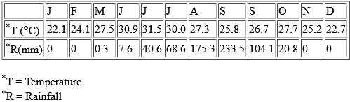
Study the table above, which shows the mean climatic conditions at station Y, and answer question below |
||
| 41. |
The mean annual rainfall of station Y is A. 54.2 mm B. 175.3 mm C. 233.5 mm D. 408.8 mm E. 650.8 mm |
A |
| 42. |
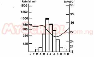 What climatic type is illustrated in the diagram above? A. Equatorial B. Sub-Equatorial C. Montane D. Mediterranean E. Monsoon |
E |
| 43. |
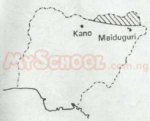 What is the correct combination of crops grown in the area shaded on the map of Nigeria above? A. 1, 4, 5 B. 3, 5, 6 C. 1, 2, 4 D. 2, 3, 4 E. 4, 5, 6 |
E |
| 44. |
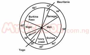 The diagram above shows the population in the French-speaking countries of West Africa in 1970. A. 3.5 million B. 3.8 million C. 4.0 million D. 4.3 million E. 4.6 million |
D |
| 45. |
 COAL MINED IN % (WORLD) A. U.S.A consumes the greatest quanity of coal B. The developed countries produce most of the world's coal C. Africa nations do not produce good quality coal D. European countries produce the best quality coal E. World trade in coal is small |
B |
| 46. |
 The perimeter of Lake Ehoma is approximately A. 15.0km B. 12.5km C. 10.0km D. 5.0km E. 7.5km |
B |
| 47. |
 The feature marked X is a A. Sand bar B. Levee C. Delta D. Peninsula E. Sand quarry |
A |
| 48. |
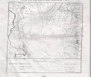 The relief feature along the western bank of the Cross River between Anofia and Unwana demostrates A. A ridge and valley topography B. A river capture in process C. The steep, undercut bank associated with meander bends D. The development of an alluvial terrace E. The steep sides of a U-shaped valley |
C |
| 49. |
 The streams flowing from the eastern part of the area do not appear to reach the Cross River probably because they A. Are remnants of streams captured by the Cross River B. Disappear underground into the underlying limestone rocks C. Flow into Ehoma and other lakes D. Disappear into swamps E. Are streams issuing out of the swamps and flowing eastwards |
C |
| 50. |
 The plain to the east of the Cross River is virtually uninhabited probably because A. It is covered by dense, impenetrable rain forests B. The land is not fertitle enough to encourage farming C. The Cross River is not navigable in this area D. The land is liable to flood E. There are too many rivers and lakes |
D |
|
Study the table above, which shows the mean climatic conditions at station Y, and answer question below |
||
| 41. |
The mean annual rainfall of station Y is A. 54.2 mm B. 175.3 mm C. 233.5 mm D. 408.8 mm E. 650.8 mm |
A |
| 42. |
What climatic type is illustrated in the diagram above? A. Equatorial B. Sub-Equatorial C. Montane D. Mediterranean E. Monsoon |
E |
| 43. |
What is the correct combination of crops grown in the area shaded on the map of Nigeria above? A. 1, 4, 5 B. 3, 5, 6 C. 1, 2, 4 D. 2, 3, 4 E. 4, 5, 6 |
E |
| 44. |
The diagram above shows the population in the French-speaking countries of West Africa in 1970. A. 3.5 million B. 3.8 million C. 4.0 million D. 4.3 million E. 4.6 million |
D |
| 45. |
COAL MINED IN % (WORLD) A. U.S.A consumes the greatest quanity of coal B. The developed countries produce most of the world's coal C. Africa nations do not produce good quality coal D. European countries produce the best quality coal E. World trade in coal is small |
B |
| 46. |
The perimeter of Lake Ehoma is approximately A. 15.0km B. 12.5km C. 10.0km D. 5.0km E. 7.5km |
B |
| 47. |
The feature marked X is a A. Sand bar B. Levee C. Delta D. Peninsula E. Sand quarry |
A |
| 48. |
The relief feature along the western bank of the Cross River between Anofia and Unwana demostrates A. A ridge and valley topography B. A river capture in process C. The steep, undercut bank associated with meander bends D. The development of an alluvial terrace E. The steep sides of a U-shaped valley |
C |
| 49. |
The streams flowing from the eastern part of the area do not appear to reach the Cross River probably because they A. Are remnants of streams captured by the Cross River B. Disappear underground into the underlying limestone rocks C. Flow into Ehoma and other lakes D. Disappear into swamps E. Are streams issuing out of the swamps and flowing eastwards |
C |
| 50. |
The plain to the east of the Cross River is virtually uninhabited probably because A. It is covered by dense, impenetrable rain forests B. The land is not fertitle enough to encourage farming C. The Cross River is not navigable in this area D. The land is liable to flood E. There are too many rivers and lakes |
D |