Year :
2004
Title :
Geography
Exam :
JAMB Exam
Paper 1 | Objectives
41 - 49 of 49 Questions
| # | Question | Ans |
|---|---|---|
| 41. |
 Express the agricultural production of Y in degrees. A. 57o B. 67o C. 37o D. 47o |
B |
| 42. |
 The diagram is a A. pie chart B. chloropeth map C. proportional graph D. bar graph |
A |
| 43. |
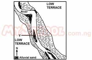 What pattern of flow did the river develop towards the southern edge of the mapped area? A. Meandering B. straight C. Braiding D. Radial |
C |
| 44. |
 In what stage of development is the river? A. Late youth B. Old age C. Early youth D. Maturity age |
B |
| 45. |
 The height of the point marked X is approximately A. 572m B. 582m C. 592m D. 562m |
D |
| 46. |
 All the settlements are located A. On top of hills B. Away from the flood plains C. On steep slopes D. On the floodplains |
A |
| 47. |
 Zara town is located in the A. Southeast B. Southwest C. Northeast D. Northwest |
C |
| 48. |
 The two likely occupations in the area are fishing and A. Lumbering B. Manufacturing C. Mining D. Farming |
D |
| 49. |
 The distance by road from Zara to Lime is approximately A. 4km B. 6km C. 10km D. 8km |
C |
| 41. |
Express the agricultural production of Y in degrees. A. 57o B. 67o C. 37o D. 47o |
B |
| 42. |
The diagram is a A. pie chart B. chloropeth map C. proportional graph D. bar graph |
A |
| 43. |
What pattern of flow did the river develop towards the southern edge of the mapped area? A. Meandering B. straight C. Braiding D. Radial |
C |
| 44. |
In what stage of development is the river? A. Late youth B. Old age C. Early youth D. Maturity age |
B |
| 45. |
The height of the point marked X is approximately A. 572m B. 582m C. 592m D. 562m |
D |
| 46. |
All the settlements are located A. On top of hills B. Away from the flood plains C. On steep slopes D. On the floodplains |
A |
| 47. |
Zara town is located in the A. Southeast B. Southwest C. Northeast D. Northwest |
C |
| 48. |
The two likely occupations in the area are fishing and A. Lumbering B. Manufacturing C. Mining D. Farming |
D |
| 49. |
The distance by road from Zara to Lime is approximately A. 4km B. 6km C. 10km D. 8km |
C |