Year :
1987
Title :
Geography
Exam :
JAMB Exam
Paper 1 | Objectives
41 - 50 of 50 Questions
| # | Question | Ans |
|---|---|---|
| 41. |
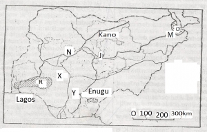 The railway extension from J to M was constructed in the 1960s to evacuate A. cotton and sorghum B. cotton and groundunts C. livestock and groundnuts D. livestock and shea-butter |
B |
| 42. |
 The temperature of the warmest month at Station X is A. 5oC B. 11oC C. 21oC D. 31oC |
A |
| 43. |
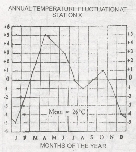 The temperature in both July and September at Station X is A. 0oC B. 2oC C. 26oC D. 28oC |
A |
| 44. |
 The annual range of temperature at Station X is A. 15oC B. 10oC C. 5oC D. 0oC |
B |
| 45. |
Which of the following represents the cheapest mode of transportation? A. Water B. Air C. Rail D. Road |
A |
| 46. |
 The area covered by the map is approximately A. 95 km2 B. 105 km2 C. 115 km2 D. 125 km2 |
C |
| 47. |
 The bearing of Jata from Adaba is approximately A. 17o B. 21o C. 25o D. 29o |
B |
| 48. |
 Intervisibility is possible between the points marked X and Y because the intervening slope is A. Rectilinear B. Concave C. Convex D. Convexo - Concave |
B |
| 49. |
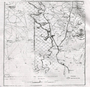 The landform feature at the centre of the map can best be described as A. A deltanic plain B. An outwash plain C. A flood plain D. An erosional plain |
C |
| 50. |
 Given that the area shown on the map is in northern Nigeria, which of the following crop combinations would best be cultivated in the area that is liable to flooding? A. Sugarcane, rice and cassava B. Cassava, rice and yam C. Sugarcane, rice and bananas D. Bananas, rice and cassava |
C |
| 41. |
The railway extension from J to M was constructed in the 1960s to evacuate A. cotton and sorghum B. cotton and groundunts C. livestock and groundnuts D. livestock and shea-butter |
B |
| 42. |
The temperature of the warmest month at Station X is A. 5oC B. 11oC C. 21oC D. 31oC |
A |
| 43. |
The temperature in both July and September at Station X is A. 0oC B. 2oC C. 26oC D. 28oC |
A |
| 44. |
The annual range of temperature at Station X is A. 15oC B. 10oC C. 5oC D. 0oC |
B |
| 45. |
Which of the following represents the cheapest mode of transportation? A. Water B. Air C. Rail D. Road |
A |
| 46. |
The area covered by the map is approximately A. 95 km2 B. 105 km2 C. 115 km2 D. 125 km2 |
C |
| 47. |
The bearing of Jata from Adaba is approximately A. 17o B. 21o C. 25o D. 29o |
B |
| 48. |
Intervisibility is possible between the points marked X and Y because the intervening slope is A. Rectilinear B. Concave C. Convex D. Convexo - Concave |
B |
| 49. |
The landform feature at the centre of the map can best be described as A. A deltanic plain B. An outwash plain C. A flood plain D. An erosional plain |
C |
| 50. |
Given that the area shown on the map is in northern Nigeria, which of the following crop combinations would best be cultivated in the area that is liable to flooding? A. Sugarcane, rice and cassava B. Cassava, rice and yam C. Sugarcane, rice and bananas D. Bananas, rice and cassava |
C |