Year :
2005
Title :
Geography
Exam :
JAMB Exam
Paper 1 | Objectives
41 - 50 of 50 Questions
| # | Question | Ans |
|---|---|---|
| 41. |
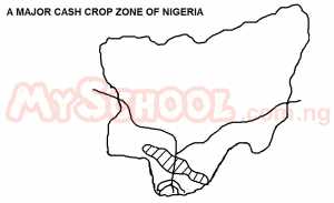 The production of the crop is usually done mainly through A. gathering from natural forest and plantation B. Plantation and large-scale irrigation C. mixed farming and small-holder cultivation D. smaller-holder cultivation and large - scale irrigation |
A |
| 42. |
 The feature shown are A. rock boulders B. disintegrated blocks C. exfoliation domes D. rounded boulders |
C |
| 43. |
 The feature are usually associated with A. dry and wet tropics B. faulted topography C. folded environments D. Karst regions |
A |
| 44. |
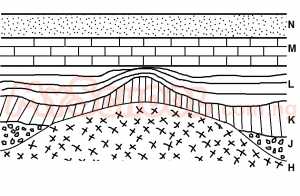 The rock that is igneous is A. H B. J C. K D. L |
C |
| 45. |
 Limestone can be identified within the area marked A. N B. M C. K D. L |
B |
| 46. |
 The total area covered by the map is approximately A. 288sq km B. 278sq km C. 258sq km D. 268sq km |
A |
| 47. |
 The railway has most probably been constructed to transport A. Passengers B. Farm produce C. Minerals D. Forest products |
C |
| 48. |
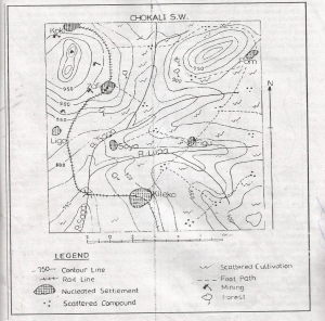 The average gradient of the rail line from the centre of Zafi to the bridge over River Saga is approximately A. 1:68 B. 1:65 C. 1:62 D. 1:59 |
A |
| 49. |
 The dominant settlement pattern in the eastern part of the map can best be described as A. Nucleated B. Linear C. Conurbated D. dispersed |
D |
| 50. |
 Places that are likely to be visible from the trigonometrical station are A. Ligo and Pom B. Figu and Ligo C. Kileko and Figu D. Pom and Kileko |
B |
| 41. |
The production of the crop is usually done mainly through A. gathering from natural forest and plantation B. Plantation and large-scale irrigation C. mixed farming and small-holder cultivation D. smaller-holder cultivation and large - scale irrigation |
A |
| 42. |
The feature shown are A. rock boulders B. disintegrated blocks C. exfoliation domes D. rounded boulders |
C |
| 43. |
The feature are usually associated with A. dry and wet tropics B. faulted topography C. folded environments D. Karst regions |
A |
| 44. |
The rock that is igneous is A. H B. J C. K D. L |
C |
| 45. |
Limestone can be identified within the area marked A. N B. M C. K D. L |
B |
| 46. |
The total area covered by the map is approximately A. 288sq km B. 278sq km C. 258sq km D. 268sq km |
A |
| 47. |
The railway has most probably been constructed to transport A. Passengers B. Farm produce C. Minerals D. Forest products |
C |
| 48. |
The average gradient of the rail line from the centre of Zafi to the bridge over River Saga is approximately A. 1:68 B. 1:65 C. 1:62 D. 1:59 |
A |
| 49. |
The dominant settlement pattern in the eastern part of the map can best be described as A. Nucleated B. Linear C. Conurbated D. dispersed |
D |
| 50. |
Places that are likely to be visible from the trigonometrical station are A. Ligo and Pom B. Figu and Ligo C. Kileko and Figu D. Pom and Kileko |
B |