Year :
1988
Title :
Geography
Exam :
JAMB Exam
Paper 1 | Objectives
41 - 50 of 50 Questions
| # | Question | Ans |
|---|---|---|
| 41. |
 The major export crop common to the countries shaded on the map is A. cocoa B. coffee C. palm produce D. sisal |
B |
| 42. |
 The Sennar Dam on the Nile river is that marked A. 1 B. 2 C. 3 D. 4 |
B |
| 43. |
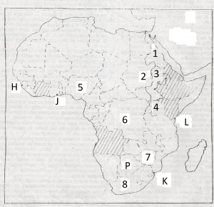 Which mineral production is common to the countries numbered 5 to 8? A. coal B. crude oil C. natural gas D. uranium |
A |
| 44. |
 Which of the ports indicated on the map does NOT have a natural harbour? A. H B. J C. K D. L |
B |
| 45. |
 The most important consideration in the siting of settlements in this area was probably A. Access to water transport B. Protection aganist external attack C. Nearness to the main road D. Availability of rich agricultural land |
C |
| 46. |
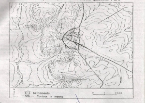 Bari Hill cannot be seen by a man standing on A. P B. Q C. R D. S |
D |
| 47. |
 The hill slope along the line X-Y can be described as A. Convex B. Concave C. Rectilinear D. Steeped |
C |
| 48. |
 The gradient of the slope X-Y is approximately A. 1:24 B. 1:26 C. 1:28 D. 1:30 |
C |
| 49. |
 The central landform in the area shown on the map can be described generally as a A. Dissected broadsurfaced escarpment B. Dissected massed inselberg lanscape C. Broken block-fault mountain D. Steep-sided tilted plateau |
A |
| 50. |
Hydraulic action and abrasion are associated with A. Aeolian erosion B. Fluvial erosion C. Karst erosion D. Glacial erosion |
B |
| 41. |
The major export crop common to the countries shaded on the map is A. cocoa B. coffee C. palm produce D. sisal |
B |
| 42. |
The Sennar Dam on the Nile river is that marked A. 1 B. 2 C. 3 D. 4 |
B |
| 43. |
Which mineral production is common to the countries numbered 5 to 8? A. coal B. crude oil C. natural gas D. uranium |
A |
| 44. |
Which of the ports indicated on the map does NOT have a natural harbour? A. H B. J C. K D. L |
B |
| 45. |
The most important consideration in the siting of settlements in this area was probably A. Access to water transport B. Protection aganist external attack C. Nearness to the main road D. Availability of rich agricultural land |
C |
| 46. |
Bari Hill cannot be seen by a man standing on A. P B. Q C. R D. S |
D |
| 47. |
The hill slope along the line X-Y can be described as A. Convex B. Concave C. Rectilinear D. Steeped |
C |
| 48. |
The gradient of the slope X-Y is approximately A. 1:24 B. 1:26 C. 1:28 D. 1:30 |
C |
| 49. |
The central landform in the area shown on the map can be described generally as a A. Dissected broadsurfaced escarpment B. Dissected massed inselberg lanscape C. Broken block-fault mountain D. Steep-sided tilted plateau |
A |
| 50. |
Hydraulic action and abrasion are associated with A. Aeolian erosion B. Fluvial erosion C. Karst erosion D. Glacial erosion |
B |