Year :
1999
Title :
Geography
Exam :
JAMB Exam
Paper 1 | Objectives
41 - 48 of 48 Questions
| # | Question | Ans |
|---|---|---|
| 41. |
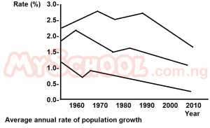 The range of population growth in the less developed regions during the period illustrated is approximately A. 2.1 to 2.7% B. 1.6 to 2.7% C. 1.4 to 2.1% D. 0.4 to 1.6% |
B |
| 42. |
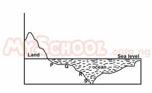 The ocean feature at point S is best described as A. a submarine ridge B. an ocean floor C. an ocean dip D. a continental edge |
C |
| 43. |
 The section labelled R represents A. An offshore beach B. a continental shelf C. a continental slope D. a marine platform |
C |
| 44. |
 A profile drawn along LK, north east of River Aye describes A. Convex slope B. Concave slope C. Straight slope D. Convex-concave slope |
C |
| 45. |
 Aperi is an example of a A. Confluence settlement B. Foothill settlement C. Wet-point settlement D. Dry-point settlement |
C |
| 46. |
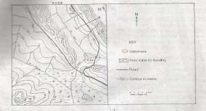 The drainage pattern of the area shown is A. Trellis B. Dendritic C. Radial D. Centripetal |
B |
| 47. |
 The prominent feature running approximately N.W to S.E is best described as A. A ridge B. A spur C. An escarpment D. An embankment |
B |
| 48. |
 The distance between the two confluences along River Kedi is A. 9.7km B. 10.7km C. 11.7km D. 12.7km |
B |
| 41. |
The range of population growth in the less developed regions during the period illustrated is approximately A. 2.1 to 2.7% B. 1.6 to 2.7% C. 1.4 to 2.1% D. 0.4 to 1.6% |
B |
| 42. |
The ocean feature at point S is best described as A. a submarine ridge B. an ocean floor C. an ocean dip D. a continental edge |
C |
| 43. |
The section labelled R represents A. An offshore beach B. a continental shelf C. a continental slope D. a marine platform |
C |
| 44. |
A profile drawn along LK, north east of River Aye describes A. Convex slope B. Concave slope C. Straight slope D. Convex-concave slope |
C |
| 45. |
Aperi is an example of a A. Confluence settlement B. Foothill settlement C. Wet-point settlement D. Dry-point settlement |
C |
| 46. |
The drainage pattern of the area shown is A. Trellis B. Dendritic C. Radial D. Centripetal |
B |
| 47. |
The prominent feature running approximately N.W to S.E is best described as A. A ridge B. A spur C. An escarpment D. An embankment |
B |
| 48. |
The distance between the two confluences along River Kedi is A. 9.7km B. 10.7km C. 11.7km D. 12.7km |
B |