Year :
1997
Title :
Geography
Exam :
JAMB Exam
Paper 1 | Objectives
41 - 50 of 50 Questions
| # | Question | Ans |
|---|---|---|
| 41. |
 The point marked with solid triangles are the locations of Nigeria's A. Thermal power stations B. International airports C. Automobile assembly D. Oil refineries |
D |
| 42. |
 The shaded areas labelled Y on the map are noted for A. Dry season wheat cultivation B. Floodland rice cultivation C. Large-scale fish farming D. Large-scale irrigation farming |
B |
| 43. |
 The shaded areas labelled X on the map indicate the probable areas of the occurrence of A. Phosphate B. Natural gas C. Marble D. Lignite |
D |
| 44. |
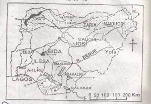 The River marked R is the River A. Gongola B. Yobe C. Gurara D. Taraba |
A |
| 45. |
 The shaded area labelled Z on the map indicates the part of Nigeria that suffers most from A. River blindness B. Tse-tse fly infestation C. Drought and desertification. D. Toxic waste pollution |
C |
| 46. |
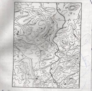 The length of the road is approximately A. 8.0km B. 8.6km C. 9.2km D. 9.8km |
C |
| 47. |
 The gradient along the main river between the points marked X and Y is approximately A. 1:15 B. 1:16 C. 1:17 D. 1:18 |
D |
| 48. |
 The feature marked P to the north-east is A. A monadnock B. A knoll C. An inselberg D. A volcano |
B |
| 49. |
 The bearing of Y from X is approximately A. 155o B. 160o C. 165o D. 170o |
B |
| 50. |
 The major constraint to road development in the area is the A. Vegetation cover B. Drainage C. Settlement pattern D. Terrain |
B |
| 41. |
The point marked with solid triangles are the locations of Nigeria's A. Thermal power stations B. International airports C. Automobile assembly D. Oil refineries |
D |
| 42. |
The shaded areas labelled Y on the map are noted for A. Dry season wheat cultivation B. Floodland rice cultivation C. Large-scale fish farming D. Large-scale irrigation farming |
B |
| 43. |
The shaded areas labelled X on the map indicate the probable areas of the occurrence of A. Phosphate B. Natural gas C. Marble D. Lignite |
D |
| 44. |
The River marked R is the River A. Gongola B. Yobe C. Gurara D. Taraba |
A |
| 45. |
The shaded area labelled Z on the map indicates the part of Nigeria that suffers most from A. River blindness B. Tse-tse fly infestation C. Drought and desertification. D. Toxic waste pollution |
C |
| 46. |
The length of the road is approximately A. 8.0km B. 8.6km C. 9.2km D. 9.8km |
C |
| 47. |
The gradient along the main river between the points marked X and Y is approximately A. 1:15 B. 1:16 C. 1:17 D. 1:18 |
D |
| 48. |
The feature marked P to the north-east is A. A monadnock B. A knoll C. An inselberg D. A volcano |
B |
| 49. |
The bearing of Y from X is approximately A. 155o B. 160o C. 165o D. 170o |
B |
| 50. |
The major constraint to road development in the area is the A. Vegetation cover B. Drainage C. Settlement pattern D. Terrain |
B |