Year :
1991
Title :
Geography
Exam :
JAMB Exam
Paper 1 | Objectives
41 - 50 of 50 Questions
| # | Question | Ans |
|---|---|---|
| 41. |
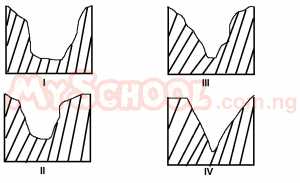 Which of the following cross sections best illustrates a glaciated valley? A. I B. II C. III D. IV |
A |
| 42. |
 The cross section marked IV best illustrate a river valley at its A. upper course B. middle course C. lower course D. source |
A |
| 43. |
Which of the following reasons BEST explains why African rivers are not very navigable? A. Low volume of water in the rivers B. Most of the rivers are too short C. Most of the river courses are interrupted by rapids D. The rivers are mostly seasonal |
C |
| 44. |
The two major air masses affecting the climate of West Africa are the A. Harmattan wind and the southwest monsoon B. Southwest monsoon and the tropical maritime C. Tropical continenal and the tropical maritime D. Warm equatorial and the tropical maritime |
C |
| 45. |
One of the places noted for irrigation agriculture in Africa is the A. Southern part of Sudan B. Ghezira Plains C. Great Rift Valley D. The Zaire Basin |
B |
| 46. |
 The highest point in the area lies above A. 300m B. 325m C. 350m D. 375m |
D |
| 47. |
 The length Owa River from its source to where it terminates in the area mapped is? A. 19km B. 20km C. 23km D. 25km |
A |
| 48. |
 There are more settlements to the south because the A. Land to the north being more fertile is reserved for farming B. Areas to the north are liable to flooding C. Terrain to the south is less rugged D. North is more prone to river blindness |
C |
| 49. |
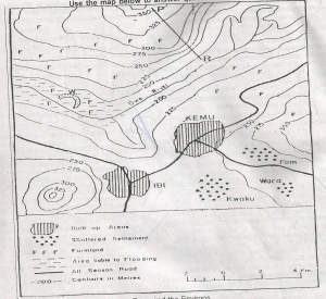 River Owa overflows its bank because A. Its valley has become shallow due to the deposition of alluvium B. The volume of water has been increased by rainfall C. Farmers block its channel with farm wastes D. Its valley is narrow |
A |
| 50. |
 Assuming that the area depicted on the map is located in the tropics, what crops are likely to thrive during the dry season in the area marked W? A. Tomatoes and onions B. Upland rice and millet C. Yams and potatoes D. Soya beans and cowpeas |
A |
| 41. |
Which of the following cross sections best illustrates a glaciated valley? A. I B. II C. III D. IV |
A |
| 42. |
The cross section marked IV best illustrate a river valley at its A. upper course B. middle course C. lower course D. source |
A |
| 43. |
Which of the following reasons BEST explains why African rivers are not very navigable? A. Low volume of water in the rivers B. Most of the rivers are too short C. Most of the river courses are interrupted by rapids D. The rivers are mostly seasonal |
C |
| 44. |
The two major air masses affecting the climate of West Africa are the A. Harmattan wind and the southwest monsoon B. Southwest monsoon and the tropical maritime C. Tropical continenal and the tropical maritime D. Warm equatorial and the tropical maritime |
C |
| 45. |
One of the places noted for irrigation agriculture in Africa is the A. Southern part of Sudan B. Ghezira Plains C. Great Rift Valley D. The Zaire Basin |
B |
| 46. |
The highest point in the area lies above A. 300m B. 325m C. 350m D. 375m |
D |
| 47. |
The length Owa River from its source to where it terminates in the area mapped is? A. 19km B. 20km C. 23km D. 25km |
A |
| 48. |
There are more settlements to the south because the A. Land to the north being more fertile is reserved for farming B. Areas to the north are liable to flooding C. Terrain to the south is less rugged D. North is more prone to river blindness |
C |
| 49. |
River Owa overflows its bank because A. Its valley has become shallow due to the deposition of alluvium B. The volume of water has been increased by rainfall C. Farmers block its channel with farm wastes D. Its valley is narrow |
A |
| 50. |
Assuming that the area depicted on the map is located in the tropics, what crops are likely to thrive during the dry season in the area marked W? A. Tomatoes and onions B. Upland rice and millet C. Yams and potatoes D. Soya beans and cowpeas |
A |